


There are roughly 800 million buildings on this earth today serving an urban population of 3.9 billion. If that population is to double by 2050, we will need an- other 600 million buildings to be built in the next 32 years. This seemingly insurmountable task is beyond the capabilities of current technologies and methods, considering that it took us few hundreds of years to build the existing 800 million
To achieve that target, we will have to re-imagine Planning, Design, Construction and Management of our built environment. New technologies will have to dramatically cut the "plan-design-build" cycle of new developments, while introducing new levels of sustainable designs and materials. In addition, these new technologies must be able to be applied onto the existing cities to make them sustainable, while most of these buildings do not even have their original drawings


Digital twin of cities
A digital twin is a virtual model of a city, a replica of the physical world. They are rapidly becoming indispensable tools to visualize the pulse of the city in real time with layered data sources of buildings, urban infrastructure, utilities, resources, businesses, people and vehicles
By digitizing cities, we can identify service gaps and opportunities and provide the means that makes a city most livable, sustainable and resilient. Digitization of assets will also allow easy access to real estate investment and fundraising - with fractional ownership and asset tokenization
•Infrastructure •Education
•Jobs •Waste Generation
•Health •Mobility
•Water •Energy
•Environment •Safety & Security
•Communication •Personal Fulfilment

Engage in digital master planning with Urbanetic
The future will be increasingly connected and fast-paced, and development practices will have to keep up. Our team at Urbanetic is ready to provide municipal governments, developers and planners software tools to translate their imagination into working, living reality with our experience in developing web-based 3D digital tools for planning, design, simulation and analysis of urban spaces
At Urbanetic, we are building tools that combine design process, data modelling, analytics and visualization to help cities find smarter and more sustainable solutions to the problems with the built environment


Fabric®
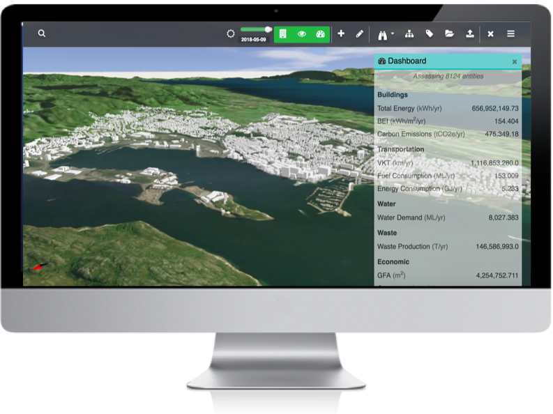
We create digital twins, or digital representations of the built environment, then infuse a variety of instrumented and non-instrumented data sets from disparate sources, in public and private domains. The result is an accurate, digital and up to date copy of your city, visualized on Fabric®
Our flagship product Fabric® helps city administrations and industries analyze their environments to learn how things work and improve the way they make decisions. From raw data to 6D parametric model Fabric® can stimulate performance in a matter of weeks by digitally representing real world assets and build sustainable built-environment
Get in Touch 
Meet your SDG goals and capitalize on your ESG assets
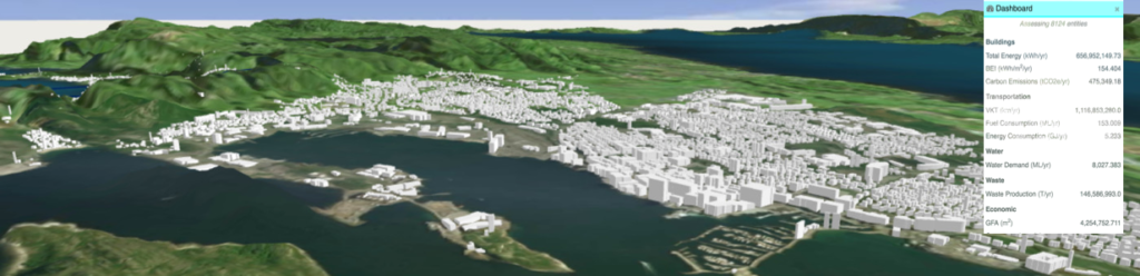
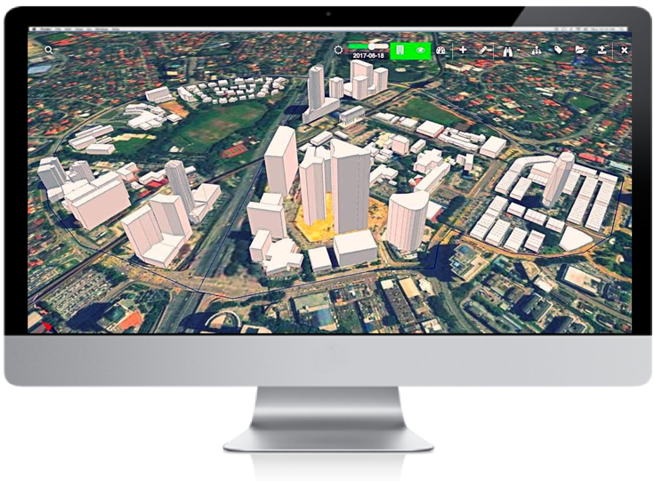
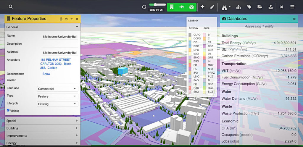
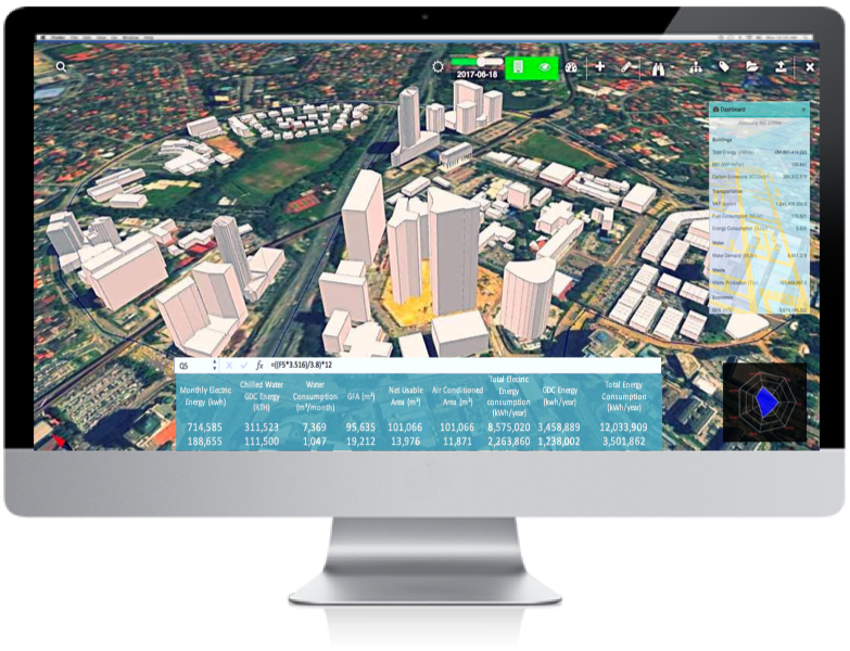
Current version of Urbanetic Fabric, comes with two core features: A city explorer with 3D visualization and an analytics feature with 6D visualization and performance dashboard. The explorer provides a visual understanding of the Urban Matrix, services and performance of the city. In analysis mode one can perform scenario simulations by changing the input variables and observe impact. 3D visualization extends 3D visualization to time, cost and performance
The development analysis feature makes it easy to understand what one can build (or rebuild) on a piece of land by providing instant, three-dimensional visualization of the development restrictions imposed by local zoning codes. At the same time, data related to development opportunities (market, regulatory, consumer, economic and environmental) are automatically proposed, and may be customized visually and interactively

Built on the cloud, Fabric® aggregates spatial, geometric, geographic, temporal. regulatory, weather, demographic and variety of other data, including real-time instrumented data - allowing you to make more informed decisions about the built environment and enabling scenario based planning models with “what-if” scenarios - aiding in the creation of high performance sustainable real world assets for the built-environment
Integration with Urbanetic's tokenization platform, TokenFab, allows the real-world digital models to be translated to and represented as ESG rated digital assets for financing and investments